
The MTA Shows Its Bias Against Buses Again
THE COMMUTE: I previously wrote about the MTA’s bias against buses and their preference for the subways. Legible bus maps for all boroughs were not available until the early 1980s. Buses were harder hit than subways in the 2010 service cutbacks. However, perhaps the most obvious example is that, for 40 years, little has been done to solve the pervasive problem of bus bunching, the bus rider’s chief complaint.
Bus tracking systems have been promised since 1980 to remedy this problem. In fact, a trial system was installed around that time in the then-newly constructed Queens Village depot but was quickly dismantled due to union objections that “Big Brother” was watching. The Transport Workers Union (TWU) was more powerful back then and the MTA didn’t want to antagonize them, fearing a strike.
That system was not GPS-based and was referred to as a bus locator system — and it worked! It let managers know where buses were within a quarter-mile so they could be better regulated. Plans were underway to expand it system-wide to minimize bus bunching.
Since then, there have been three failed attempts at tracking the location of buses using GPS technology. The New York Daily News recently summarized these three failed attempts.
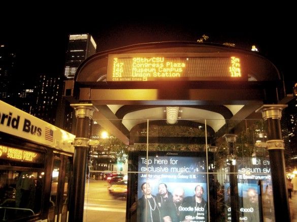
Now the MTA is focusing on Bus Time, a system already in place on one Brooklyn route, and on all Staten Island routes, giving little assurance that it will be used to help regulate buses. The focus now is merely to let riders know how far away their bus is. The original intention of Bus Time was to let riders know, in minutes, the bus’ estimated arrival time in a way similar to that of the subway countdown clocks. Thus far, only the distance the bus has to travel to reach the stop where you are waiting is available. This information is of limited value.
How useful is it to know that the bus is a block or two away when, in most cases, you can see the bus coming anyway? The real value is in knowing if the bus is 10 minutes away, or 30 minutes away. Knowing that the bus is a mile and a quarter away does not tell you much. Currently, all that can be provided is distance due to the uncertainty of traffic conditions. One would think that there is enough historical traffic data in any given area to provide a reasonably accurate estimate of how long traffic will delay the bus. Hopefully, this problem will be resolved soon. There would always be some unknowns, however, such as not being able to predict accidents or if a wheelchair passenger boards or alights.
Further, this information will only be available via smart phone or text message and will not also be displayed on bus shelters as originally intended. Councilman Brad Lander is introducing legislation requiring the MTA to provide the information on the bus shelter. Providing this information on the shelters has additional advantages. Currently the M34 SBS is treated separately from the M34A SBS, requiring two separate calls or text messages if either bus could be taken. Displaying the information for both routes on the shelters would provide much greater utility.
Unanswered Questions
Why have there been four failed attempts costing countless millions to determine where buses are on their routes and how much of this is the MTA’s fault?
The MTA has, for years, successfully used GPS to track its fleet of armored cars all over the city, including Midtown, so why was it having such difficulty tracking its buses?
Why initiate a program in 1996 in the most difficult area, Midtown Manhattan, where there are known GPS technological issues due to skyscrapers? Why not begin in the outer boroughs where bus bunching is just as much of a problem and there are few skyscrapers?
Why was there a second attempt to install GPS tracking in Manhattan in 2005, thus wasting another $13 million without resolving the problems that arose during the first pilot?
Why in Chicago can the distance a bus is from a bus stop be successfully converted to time, and be displayed clearly on a bus shelter and not here? (Bus maps are also displayed on its shelters — something else we do not do here.)
Has the MTA abandoned attempts to convert distance to estimated times of arrival? If so, that is unacceptable.
Where Is The Accountability?
Why is the primary focus of GPS tracking to let passengers know the location of buses, rather than to inform management so buses can be better controlled? After all, Bus Time would not even be necessary if buses were relatively on time. It’s like a doctor saying, “Since I can’t cure your condition, I will tell you how much time you have left to live. Will that be good enough?
Why is CEMUSA not being held to their contract responsibility to provide transit information at bus shelters? Route numbers and maps are being removed and replaced with transit tips and many shelters do not even have the tips. Adding lit up bus schedules to shelters becomes more important if bus arrival times are not installed.
Conclusion
Apparently, in its ongoing bias against buses, subway riders are deemed worthy of having countdown clocks. Subway riders will even have a cell signal in subway stations as the MTA moves forward with its plans. Given all the other transit problems, is this really that important? But bus riders? Not so worthy. Unlike subway riders, a cell phone will be required to know where the next bus is and knowing only the distance and not the estimated time of arrival may be considered sufficient for bus riders.
What about using GPS technology to better regulate the buses, since the number of dispatchers has been cut to a minimum? Well, good luck on that one. After 40 years of responding to concerns about bus bunching by promising the problem would be solved once GPS is installed, no such recent promises have been made in that regard.
The MTA is returning to their original stance that traffic is not their responsibility and they have no control over it. Is it any wonder why the MTA has little credibility and an image problem? Bottom line: Don’t expect system-wide improvements regarding bus reliability in the foreseeable future.
The Commute is a weekly feature highlighting news and information about the city’s mass transit system and transportation infrastructure. It is written by Allan Rosen, a Manhattan Beach resident and former Director of MTA/NYC Transit Bus Planning (1981).
Disclaimer: The above is an opinion column and may not represent the thoughts or position of Sheepshead Bites. Based upon their expertise in their respective fields, our columnists are responsible for fact-checking their own work, and their submissions are edited only for length, grammar and clarity. If you would like to submit an opinion piece or become a regularly featured contributor, please e-mail nberke [at] sheepsheadbites [dot] com.


