
North Williamsburg Transportation Study, Part 2: Recommendations


The North Williamsburg traffic study is finally here… almost. While the final report is due to be released by the Department of Transportation in the near future, the DOT has already begun presenting the findings to a community that has waited patiently for results since the study was first announced in 2016.
At a sparsely attended meeting at P.S. 84 last Thursday, a DOT spokesperson presented the study’s findings to about 20 residents and community leaders, along with representatives from local councilmembers Levin and Reynoso’s offices.
There are 10 major improvements outlined in the North Williamsburg Transportation Study. While they are all referred to as recommendations in the presentation, the DOT has already begun implementing some of the projects, while others will move from recommendation to project later on.
These are tje six projects that the DOT currently has designated as recommendations, but despite their title, they are all going be implemented eventually, according to the DOT’s presentation last week. These future projects are as follows:
1. Franklin Street/Banker Street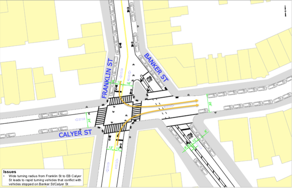
The local community has long called upon city officials to do something about the intersection of Franklin and Banker Streets, which intersect at Calyer and create a dangerous situation for drivers and pedestrians alike.
With two-way traffic making the turn from Franklin onto eastbound Calyer, then immediately crossing Banker, there’s often confusion. Additionally, the wide radius allows drivers to make the turn at potentially unsafe speeds. Finally, there’s little in the way of protections or guidance for pedestrians on Banker Street.
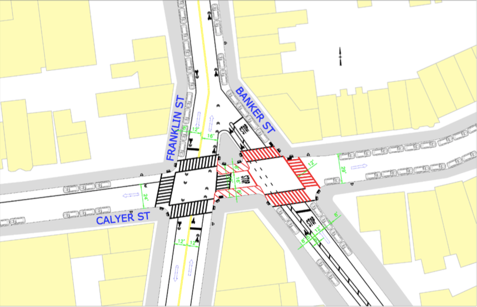
The DOT has two proposed plans for the intersection, which can be seen below:
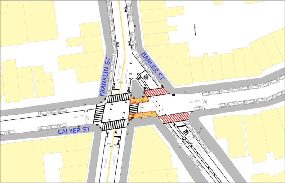
In the first, curb extensions at the center of the intersection would slow turning cars and shorten the pedestrian crossing over Calyer Street, while creating high-visibility crosswalks across Banker on both sides of Calyer.
The second proposal relies on a stop sign in the middle of the intersection, with painted markings area, along with more high-viz sidewalks, including another crossing of Calyer on the east side of Banker Street. The DOT will continue monitoring the location to determine the best course of action.
2. Broadway at BoerumSimilar to the adjustments being implemented along Broadway at Union and Debevoise, the recommendation at Boerum is to create a curb extension out to the column of the elevated train track to reduce the danger to pedestrians. Once again, it would rely on a combination of flexible delineators and concrete blocks with paint to make the space.
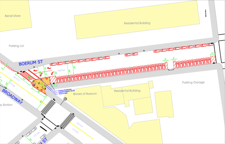
This solution, however, would mean flipping the current situation of angle parking on the north side of the street in front of the Lindsay Houses and Sternberg Park, switching to back-in parking on the south side—not only to Lorimer, but for two more blocks, across Leonard to Manhattan Avenue:
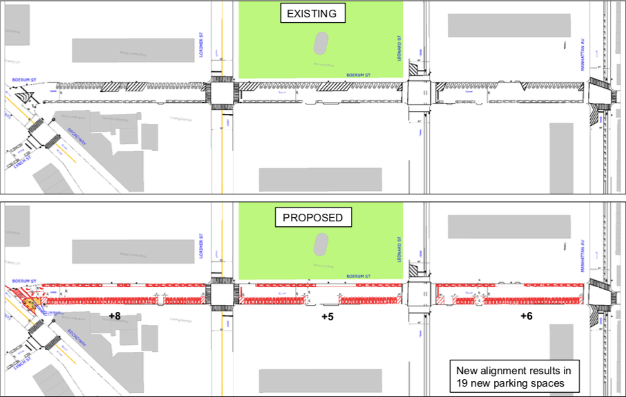
While most drivers are hyper-aware of changes to parking that could result in a loss of spaces, the DOT has determined the new arrangement would actually create 19 new parking spots.
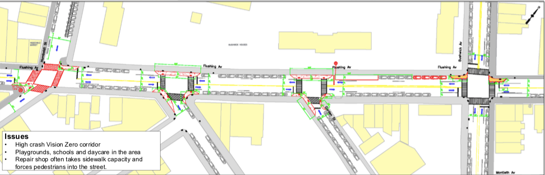
3. Flushing Ave between Humboldt and Bushwick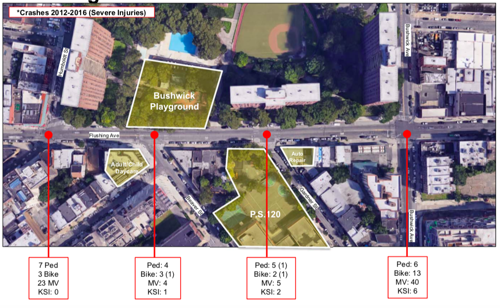
In the short section of Flushing Avenue that runs past the Bushwick Houses and P.S. 120, four streets intersect with the road, including two T-junctions at Beaver and Gardner Streets. With the playground, adult/child daycare and schools so close, additional safety measures are required.
Since 2016, the streets have seen 9 deaths or serious injuries and more than 100 accidents between bikes, cars and pedestrians, making it a Vision Zero high crash corridor.
The DOT’s recommendation would create bump-outs and vurb extensions to slow turning cars, as well as eliminating parking between crosswalks at the T-junctions to create more visibility for pedestrians as drivers negotiate the intersection:
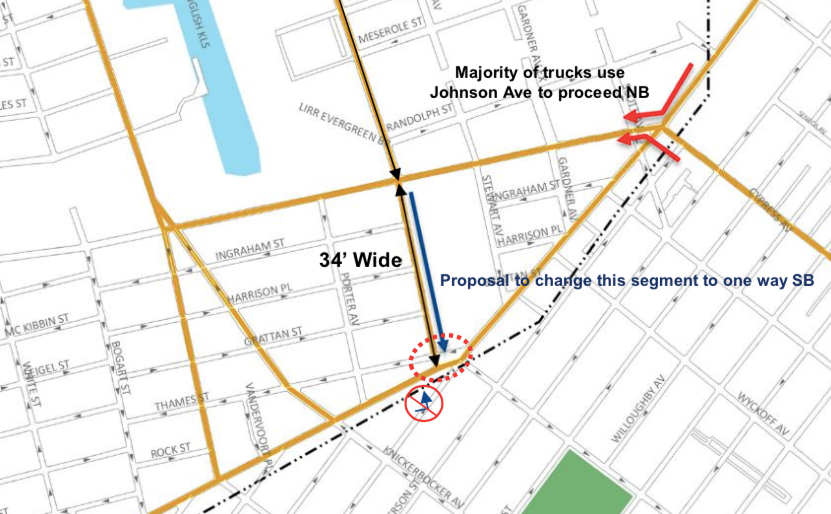
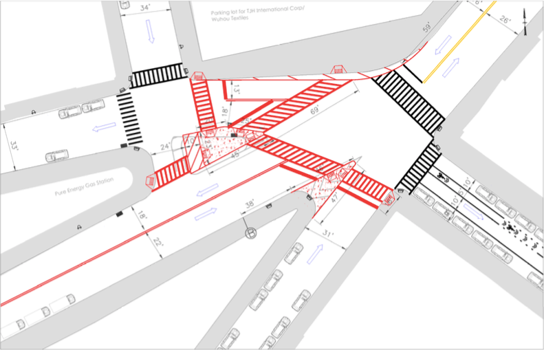
Over in Bushwick, the DOT recommends a change in Varick Avenue’s direction, switching to one-way southbound traffic that will hopefully only affect truck traffic in the area.
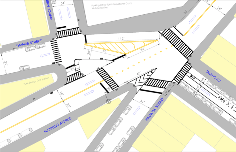
For pedestrians, the DOT has proposed a couple new crosswalks to make navigating the Jenga-like structure of the blocks a bit easier, along with a concrete curb extension where there was previously just a painted one. View the current layout and the proposed changes in the slides below:
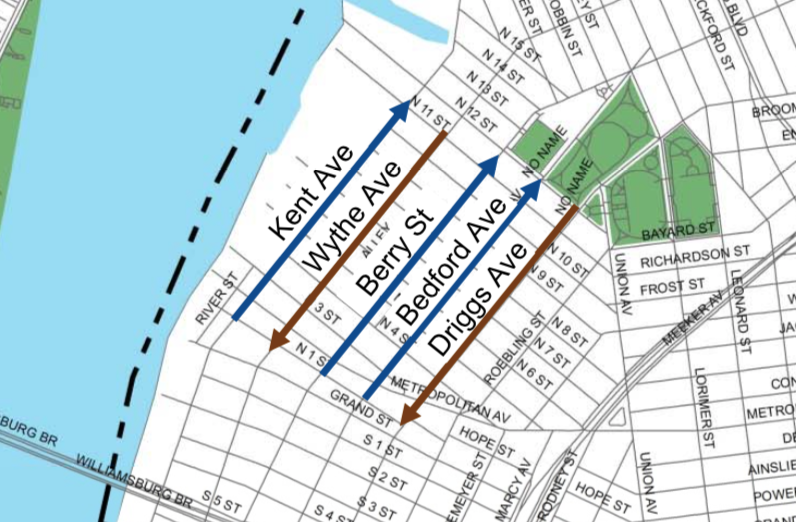
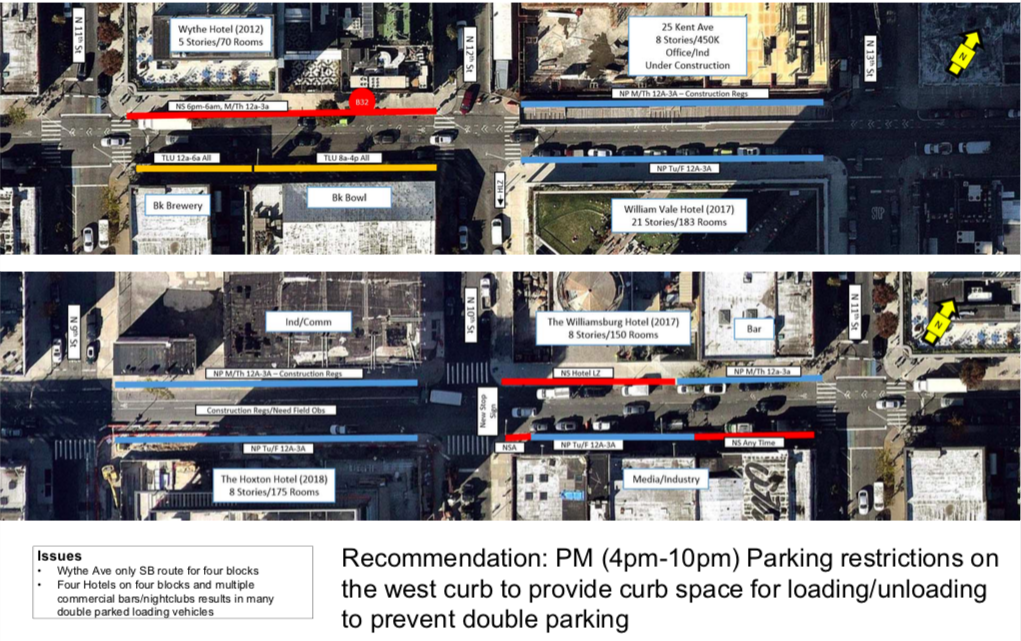
With the large amount of traffic on Wythe Avenue, the only southbound stree for a span of four blocks in the west end of Williamsburg, the DOT is recommending parking restrictions to allow more room for loading and unloading of commercial vehicles.
With four hotels in four blocks and multiple nightlife venues in the area, parking is at a premium while businesses with busy delivery schedules try to keep up—which often leads to double-parked delivery vehicles slowing down traffic on the only southbound street.
The DOT recommends parking restrictions on the west side of the street in the evenings, from 4:00 pm to 10:00 pm, in order to give room to commercial vehicles for loading and unloading.
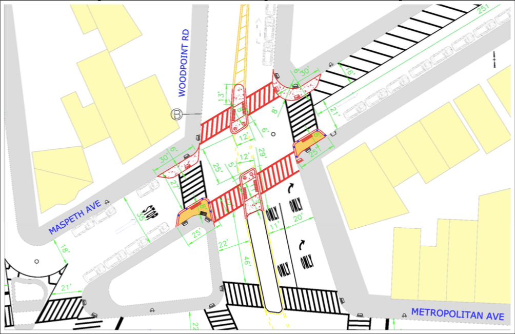
Finally, the DOT is recommending pedestrian improvements to the intersection of Maspeth Avenue and Woodpoint Road, an intersection without a signal that presents difficulties to pedestrians.
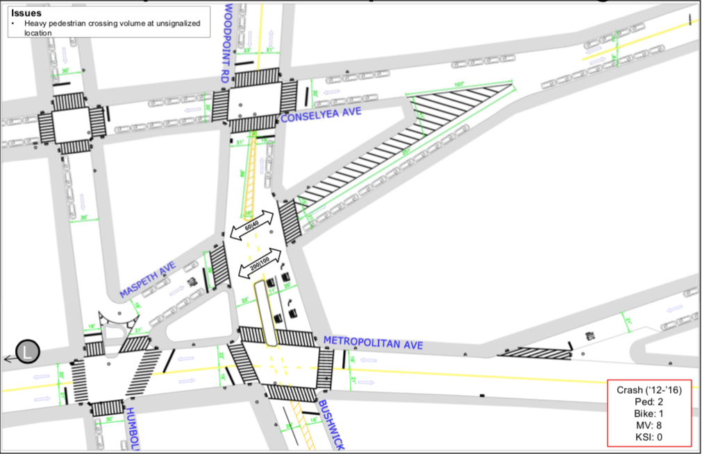
The short section of road between Conselyea and Metropolitan proves difficult to navigate, with pedestrians often waiting for gaps in traffic to make risky crossings. The large intersection has no east/west crossings marked, but sees heavy foot traffic as pedestrians make their way from the eastern residential areas to the Graham Avenue L train station.
The DOT’s recommended improvements would create new marked crosswalks along with pedestrian islands to shorten the crossings and cut down pedestrian exposure to traffic:
These six plans, part of the larger North Williamsburg Transportation Study, are at this time still just recommendations. But according to the DOT spokesperson last week, they will eventually move into implementation—and it’s unclear what time of community feedback will come between to two phases.
Tonight, the DOT will be presenting much of this information at the Community Board 1 meeting and may have time for public comment. The meeting is at 211 Ainslie Street, starting at 6:00 pm, Tuesday, June 12.


