
Mayor’s Misleading ZIP Code Talk Means Zip

There has been so much talk of ZIP codes recently. COVID-19 hot spot areas, watch areas, areas where schools are or are to be closed, and where other restrictions on businesses and gatherings may be imposed come Wednesday.
Ever since the talk of the Ocean Parkway Cluster, Mayor Bill de Blasio has been dismissing the 9 ZIP codes in high infection rate area as concerning, but a small number.
Most recently the Mayor told Alisyn Camerota on CNN’s New Day Monday morning “Well, right now, it is 9 ZIP codes out of the 146 ZIP codes in New York City that we’re particularly concerned about, Alisyn, and then there’s another 11 we’re watching very carefully. So, look, the truth is the vast majority of New York City, we continue to see what we’ve seen for months, thank God, low levels of transmission.” He’s been referring to these 146 ZIP codes for over a week.
Just what is he talking about when he refers to these ZIP codes? We don’t know (and we asked his press office repeatedly). According to the USPS, there are 315 ZIP codes in NYC. Manhattan alone has a 148, Queens – 80, Brooklyn – 48, the Bronx – 25, and Staten Island – 14.
“ZIP Codes can mean different things. They can be designated to an entire area of a city or one single building. ZIP Codes are not based on density or population. They are simply to help USPS sort the mail as efficiently as we can,” explained Amy Gibbs, Strategic Communications Specialist for the USPS.
“The codes themselves do not represent geographic regions; in general, they correspond to address groups or delivery routes. Therefore, ZIP Code “areas” can overlap, be subsets of each other, or be artificial constructs with no geographic area – such as a mail processing plant within an individual ZIP Code,” she added.
“In the case of Williamsburg, as the area grew denser, the Postal Service system began to run out of ZIP+4 combinations. There is a finite number of combinations. Thus, the solution was to break 11211 into two ZIP Codes, adding the 11249 ZIP Code and a new set of possibilities for the ZIP+4 digits.”
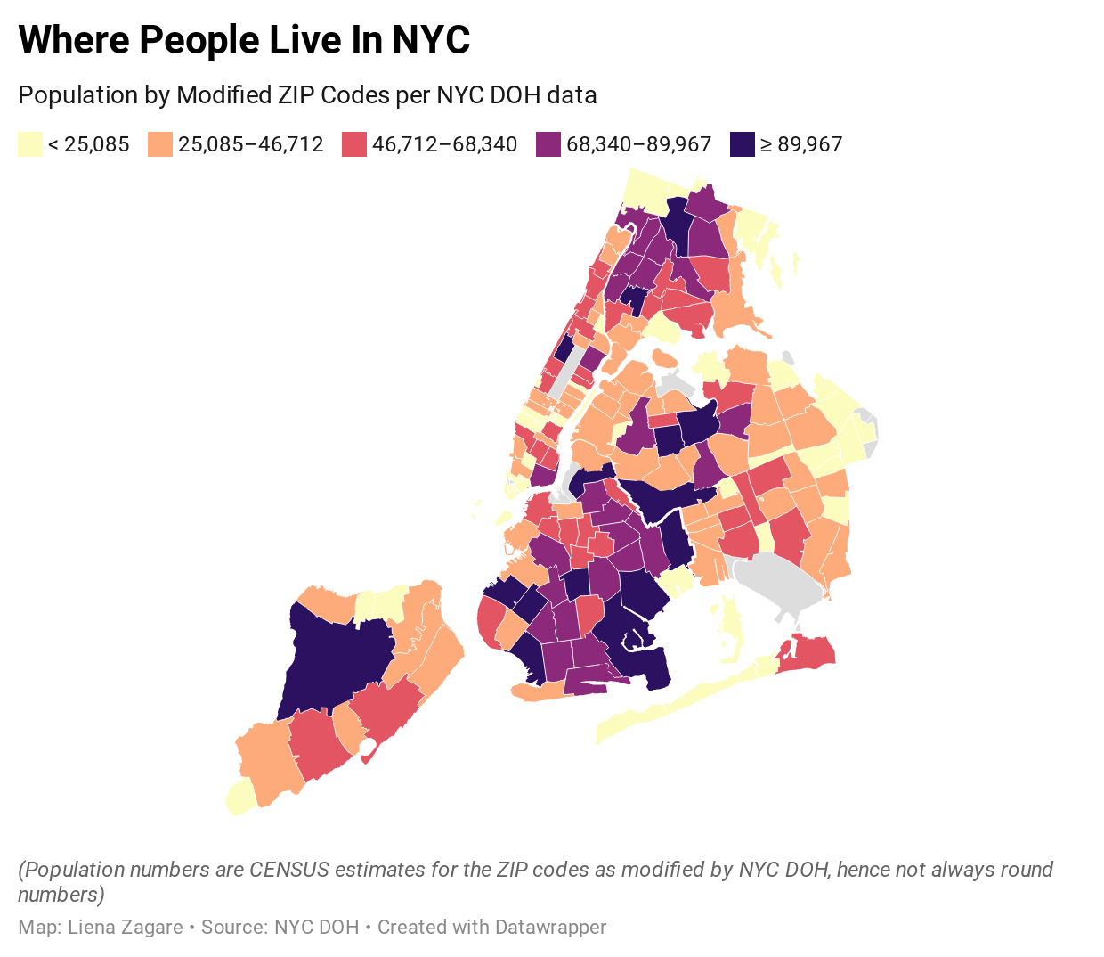
However, many ZIP codes do cover significant geographic areas, and NYC Department of Health (DOH) has been using modified ZIP-codes to release neighborhood-level health data, even though the overlap of ZIP codes and neighborhoods is far from perfect.
Currently, DOH is using 177 ZIP codes to release such information, and it is accompanied by data on population estimates for each (which is not always a round number).
!function(){"use strict";window.addEventListener("message",(function(a){if(void 0!==a.data["datawrapper-height"])for(var e in a.data["datawrapper-height"]){var t=document.getElementById("datawrapper-chart-"+e)||document.querySelector("iframe[src*='"+e+"']");t&&(t.style.height=a.data["datawrapper-height"][e]+"px")}}))}();
We mapped that data. The map above shows where people live in NYC by ZIP codes used by the current administration to make decisions. So when the Mayor says its just these 9 or 20 ZIP codes, it really matters which ones, because the ZIP codes say in the Financial District contain just over 3,000 residents, whereas Corona in Queens has over 111,000.
So what does all this mean for Brooklyn?
!function(){"use strict";window.addEventListener("message",(function(a){if(void 0!==a.data["datawrapper-height"])for(var e in a.data["datawrapper-height"]){var t=document.getElementById("datawrapper-chart-"+e)||document.querySelector("iframe[src*='"+e+"']");t&&(t.style.height=a.data["datawrapper-height"][e]+"px")}}))}();
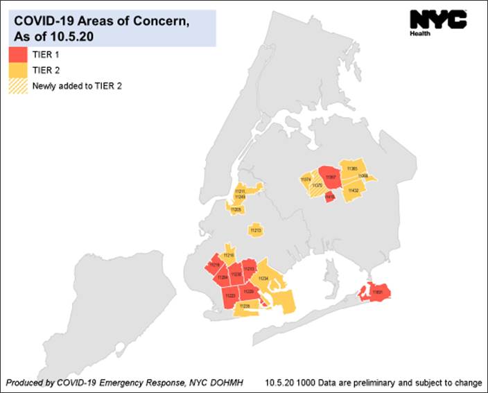
You have seen this table before – it is what the NYC DOH shares in its updates on “areas of concern” for the spread of COVID-19, we just added a column on population numbers for each of those ZIP codes.
If you add all the Brooklyn Tier 1 areas, where infection rates have been above 3% for over a week or two, you are looking at 493,302 people, or 19.1% of Brooklyn’s total population, which is estimated to be 2,582,830 or so people. Another 458,685 or 17.8% reside in the Tier 2 watched areas – all in all, 36.86% of all Brooklyn residents currently reside in the affected areas.
So when you hear numbers like “it’s just 8% of the city,” it is not telling you the whole truth. Yes, Tier 1 group of ZIP codes does currently account for 8.25% of the city’s residents.
But – Brooklyn accounts for 34% of all NYC residents. The numbers that should be talked about are how essentially half of Brooklyn is in a COVID-19 hot zone, and that the areas surrounding the Tier 1 ZIP codes are some of the most populous ones in the City – like for example 11235 for Sheepshead (about to move from Tier 2 to Tier 1) has over 95,000 residents. 11214 – Bensonhurst – also has over 90,000 residents, and borders 11223 and 11204 – both in Tier 1. Comparable infection rate information for this zip code is not readily available.
When asked about how appropriate use of ZIP codes is, the Mayor responded this morning that “based on the guidance I’m getting from our health leadership, the folks who’ve been fighting all the way through this crisis, that the ZIP code is the best available measure we have, because if you look at these ZIP codes throughout them, you’re seeing either very high rates or unfortunately growing rates in the peripheral areas of the ZIP code.
“So, say for example, one part of the ZIP code is having a particularly intense problem that does not mean the other areas of immediately it in the ZIP code are just plain fine. Unfortunately, what we’re seeing is some crossover to other areas as well, surrounding. So overwhelmingly, these ZIP codes are areas of concern across the board. It’s not as clean as you know, the western half of the ZIP codes really troubled on the eastern half is just plain fine and perfect. No, we’re seeing the whole ZIP code in many cases, having some degree or another of a higher level of positivity. We also think it’s important if we’ve got an area that’s really intense in terms of high positivity to surround it with the protections we put in place. So, it doesn’t spread to even more ZIP codes. So, from my point of view, this is the best usable measure.”
It may be the “best usable measure” but it is high time the City stopped misleading its residents by the data it chooses to release and how.


