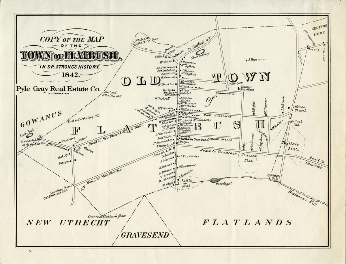
Map Of The Week: Town Of Flatbush, 1842


[This story was updated with additional information at 4:30pm, 9/21/16.]
On a recent visit to the historic Lefferts family homestead in Prospect Park, I saw this map of the town of Flatbush in 1842.
The map is intriguing for a variety of reasons. In 1842, Flatbush was still a rural community, independent of both the cities of Brooklyn and New York — yet it already stood at a crossroads for Kings County.
It is unclear whether the map is to scale. Reproduced by the Pyle-Gray Real Estate Company (and based on a town history probably written by Thomas Strong), the map shows Flatbush Avenue (then Flatbush Road) as the spine of the village, running north-south.
Church Avenue to the east of Flatbush is called “East Broadway” in 1842. Note the “African Church” shown where East Broadway seems to intersect with Kings Highway.
Church Avenue heading west, through what is now Kensington, is called the “Road to New Utrecht & Bath.”
To the north, Clarkson Street in Prospect Lefferts Garden is already visible. The properties of families whose names are still very familiar to us — such as Ditmas, Bergen and Lott — can be seen along Flatbush Road.
You can also see the location of the original Erasmus Hall Academy building on the east side of Flatbush, which is still located on the Erasmus campus today.
Paerdegat Pond
Towards the bottom of the map one can see what appears to be Paerdegat Pond (possibly near what is today Foster Avenue). The pond was the town’s source of drinking water. Even after consolidation with Kings County and then the City of New York in 1898, Flatbush residents continued to use the pond, which was situated on the outskirts of the original village and surrounded by an old forest.
It was not until 1949 that Paerdegat Pond was buried and the last of the forest was cleared. The housing development that would become Flatbush Gardens was constructed on the 30-acre former site of the pond and forest.
The “Flats”
You will also notice three “flats” on the map — Corlear’s Flats, Twiller’s Flats and Little Flats. They are discussed in a 19th century history of Flatbush written by Thomas M. Strong, D. D., who describes himself as the pastor of the Reformed Dutch Church of Flatbush.
(This may very well be the same Strong who created the map that is the subject of this article.)
Strong writes that he prepared the history “as a part of a course of Lectures by the ‘Flatbush Literary association,’ during the winter of 1841-2.” He continues below:
It would appear that about the year 1634, the settlement of Flatbush commenced. It then comprised a tract of woodland bounded on the north by the Hills [now Prospect Park], on the south by Flatlands, and extending east and west in one continual forest.
This tract was evidently purchased by the governor of the colony, or by the first settlers, from the native Indian proprietors, but the amount of consideration paid cannot now be ascertained.
At the time of the purchase, it was heavily covered with timber, (consisting principally of hickory and white and black oak,) with the exception of two small parcels which were clear and destitute of trees, lying to the east of the town, then called by the names of Corlaer’s and Twiller’s Flats, and another on the south of the town adjoining Flatlands, called the Little Flats.
The land thus described, from its being principally covered with timber, and from its peculiar location, having the hills on the north and Flatlands on the south, was appropriately called by the first settlers, by the name of Midwout, or Middlewoods.
More Questions
Can you help me figure out more about this map? I didn’t recognize the Vernon Avenue that is shown but a reader has just sent a fabulous map from the 1870s (see the comments below). Vernon Avenue may actually be Tilden Avenue.
Also take a look at the “Road to Canarsey”. Could this be Cortelyou Road?


