
Ditmas Park Is Not Part Of Flatbush, Says New York Times


A New York Times article Friday extolled New York City’s “Next Hot Neighborhoods.” Not totally surprisingly, the Times has flagged Sunset Park West, Flatbush, the Rockaways, and East Harlem as areas that will see surging property values.
Times reporter Michelle Higgins presents Ditmas Park as a neighborhood separate from Flatbush. But that expansive area with roots dating back to the 1600s was widely understood as extending all the way west to Coney Island Avenue well into the 20th century.
Higgins defines Flatbush as: “Parkside Avenue to the north and the Long Island Rail Road tracks to the South at Avenue H….between Ocean and New York Avenues.” She describes Ditmas Park as the neighborhood, “right next door.”
“With stately Victorians selling for more than $2 million in Ditmas Park and luxury rentals on the rise in Prospect-Lefferts Gardens, where is a Brooklyn buyer with a starter budget to turn? The answer may be right next door.
Flatbush, which is roughly bounded by Parkside Avenue to the north and the Long Island Rail Road tracks to the South at Avenue H and is between Ocean and New York Avenues, has the allure of lower prices. The median sales price was $330,000 at the end of last year, compared with $530,150 in Prospect-Lefferts Gardens and $700,000 in Ditmas Park, according to StreetEasy.com.”
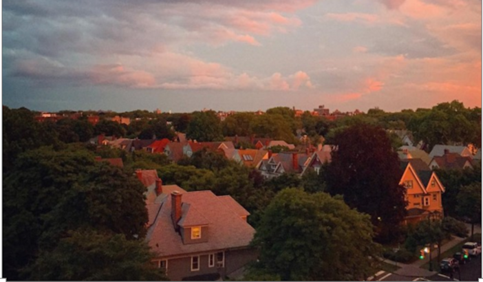
As we reported in 2012, Ditmas Park’s original boundaries extended from the Brighton Beach rail line (now the B/Q subway line) east to Ocean Avenue, between Dorchester Road and Newkirk Avenue. The original Ditmas Park was a relatively narrow strip of land.
Note that the developer — Lewis H. Pounds — describes the area as “the best location in Flatbush.”

When Ditmas Park was under construction in the early 1900’s, other sections of what we understand today as “Victorian Flatbush” — Prospect Park South, Beverley Square East and West, Fiske Terrace, etc. — were also being developed. These new mini-districts extended all the way west to Coney Island Avenue.
Today, the term “Ditmas Park” is commonly used to describe the western part of Flatbush as far south as Newkirk Avenue.
But even in the 1940s, the area of Brooklyn spanning from Coney Island Avenue east to New York Avenue was considered “Flatbush.”
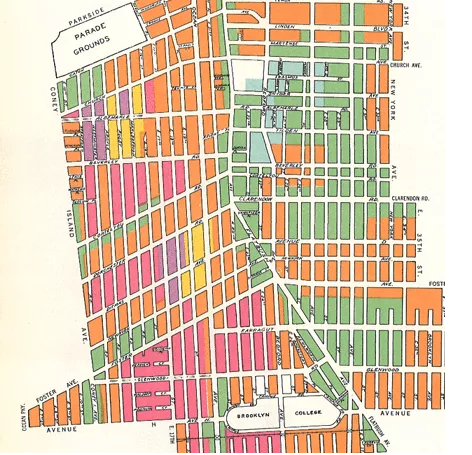
In the 1960s and 1970s, large numbers of whites left Flatbush, especially areas east of Ocean Avenue. Eventually, the real estate industry began to present areas areas west of Ocean Avenue as being distinct from “Flatbush.”
In the 1940s, according to the map above, a home in Prospect Park South would have been advertised as being in Flatbush, but this has not been the case for several decades, neighbors tell us. Flatbush shrank in size.
Higgins has stumbled into the bigger, much more important question of what the word “Flatbush” means today. And it’s a complex question, tied as much to physical and historical boundaries, as it is to demographics and the efforts of the real estate industry to increase property values.
But from a historical perspective, yes, Ditmas Park is very much part of Flatbush. And just as importantly, this historic area’s population is in a near constant state of flux. Perhaps the reality is that there are many Flatbushes — and Ditmas Park is just one of them.
What do you think?


