
The Commute: Why We Need A Moratorium On Future SBS Routes – Part 4 Of 5

THE COMMUTE: In Part 3, we discussed community involvement.
SBS Future Plans
New York City Department of Transportation (DOT) Commissioner Polly Trottenberg announced at a February 10, 2015 City Council hearing that the next Select Bus Service (SBS) route would be 86th Street in Manhattan because it will be “easy.” It will not include exclusive bus lanes but still will be called SBS because of the fare prepayment feature and articulated buses it might use. Virtually all existing bus stops will remain in place, unlike most other SBS routes in which bus stops have been removed. Construction will begin this spring.
Also planned for quick implementation are SBS on the Utica Avenue B46, which is the second busiest bus route in the city, at 50,000 daily riders a day; a Flushing to Jamaica SBS, and a Woodhaven Boulevard route. The SBS ‘propaganda’ and the Phase 2 Corridors can be viewed in this report.
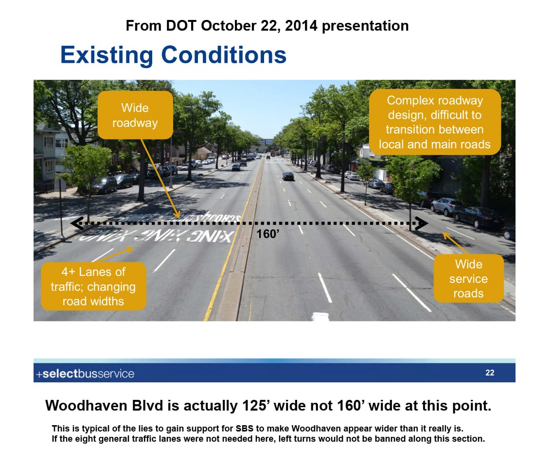
It Appears That DOT Has Decided On BRT For Woodhaven-Cross Bay Boulevard
We should find out for sure at the Community Advisory Committee Hearing to be held on March 11. I discussed Woodhaven Boulevard before. The Bus Rapid Transit (BRT) differs from SBS in that the bus lanes are physically separated from other traffic, cannot be used for right turns, are in effect 24/7, feature elaborate bus stations, and could be placed in the center median. The cost is also about 20 times as much.
So what do we get for the extra money? And is it worth it? Again, no clear answers are provided. The only statement we get from DOT is filled with vague generalities, such as BRT provides “more robust features” and “Woodhaven is a real opportunity for something bigger and bolder.” Three million dollars is being set aside just for the design phase. The terms BRT and SBS are used interchangeably on their website.
The cost to reactivate the nearby parallel Rockaway Beach Line (RBL), which would cut travel time in half between Rego Park and Liberty Avenue, is about $650 million and would provide other benefits such as spurring development. The Metropolitan Transportation Authority (MTA) and DOT are ignoring that option. Councilman Brad Lander, seemingly unaware of the RBL option, compared BRT to the cost of constructing the Second Avenue Subway, calling BRT a bargain, although no one has proposed a subway under Woodhaven Boulevard. We are asked to accept an expenditure of what could be $400 million just because DOT claims it is “bigger and bolder” and therefore worthwhile. Shame on our Council members for accepting DOT’s claim without a shred of proof.
The DOT and the MTA state only that 30,000 daily bus riders would benefit from SBS or BRT. They do not even quantify how many minutes of travel time would be cut from their commute. Although the time-savings bus riders would achieve would be higher than on SBS routes already implemented because 30 percent of Woodhaven riders travel from nearly one end of the route to the other, according to the MTA, it still might not be worthwhile since bus riders account for only 33 percent of the users of Woodhaven and Cross Bay Boulevards. The predominant traffic is auto and truck during non-rush hours, perhaps 80 percent. Car ownership in zip codes adjacent to Woodhaven is also above 80 percent, much higher than the city-wide average of 44 percent. So what would it mean if two lanes were permanently taken away from them 24/7 as required by BRT with physically separated lanes?
When all commuters are considered, it would mean more time is lost than is gained, and an unwise expenditure when you consider the RBL option, which doesn’t remove any traffic lanes, and could also accommodate BRT. The DOT does not yet have the money to fund BRT and may not get it. Their plan is to use as much federal money as becomes available so they can provide the most BRT features possible.
Ten Unanswered Questions About Woodhaven
- What are the additional benefits true BRT will provide over SBS that it is worth 20 times the cost?
- If the center alignment is chosen, how will buses shift to the outer roadway at Atlantic Avenue and how will that impact traffic? If they use the overpass, transferring bus passengers will no longer have a convenient bus transfer and will have to walk several blocks to transfer.
- If the bus lane is located in the main roadway, but not in the center median, how will other traffic move between the two lanes in the center roadway to the lane in the service road? Or will no lane changes be allowed? If that is so, how will that impact traffic with only two through lanes? The DOT has only showed the communities bits and pieces of the plan without thus far revealing the entire design for each and every block, and the hours of operation for exclusive bus lanes.
- Where will left turns be permitted and where they will be banned? Drivers need to have advance notice as to the location of the next left turn. Currently it is a guessing game with even DOT officials admitting to getting lost while traveling to one of the meetings. Plans show the elimination of all left turns at Metropolitan Avenue and Rockaway Boulevard, locations where I observed 50 cars waiting to make left turns during the midday. Only about half were able to get through on the first cycle.
- Where will these cars turn when the turns are prohibited? How much longer will it take to traverse the additional quarter-mile that will be required? These questions must be answered with reliable data and projections. Thus far only scant data has been provided which hasn’t included a single traffic count, although traffic counts were requested by the Queens Public Transit Committee, along with other data, last April, almost one year ago.
- How can the DOT and MTA insist there is adequate community involvement when they ignore repeated requests to provide necessary data?
- When will DOT prove that BRT will not slow down other traffic to a crawl, or gridlock during rush hours, and not just make a wild allegation that all traffic will flow better? No traffic data or any data have been presented from New York City Transit’s (NYCT) transit forecasting model for any past or proposed SBS corridor. The model is referred to on Page 1 of this report prepared in 2009, outlining future SBS corridors based on “underserved areas.” In fact, the Woodhaven Corridor was not even listed as a potential SBS route. It was added later due to pressure from groups such as Transportation Alternatives.
- How will the DOT and MTA achieve taking cars off the road to reduce traffic congestion along Woodhaven/Cross Bay Boulevard? Many vehicles coming from southern Brooklyn and southeast Queens now take the Belt Parkway or North Conduit Avenue or South Conduit Avenue to Cross Bay Boulevard or Woodhaven Boulevard to access various parts of Queens. However, there are no bus routes from southern Brooklyn and none are proposed that might transfer to the proposed SBS routes.
- Why would any future east/west SBS routes between southern Brooklyn and John F. Kennedy (JFK) Airport stop at Cross Bay Boulevard, thus enabling southern Brooklyn residents traveling to Queens to switch from their car to SBS? The B15, the only Brooklyn route south of Atlantic Avenue to enter Queens (not counting routes at the borough borders) travels non-stop between 79th Street/Linden Boulevard and JFK without stopping at Cross Bay Boulevard. Only two southern Queens bus routes transfer at Cross Bay Boulevard. NIMBYs from local communities near Cross Bay Boulevard have been known to oppose better Brooklyn / Queens connections.
- If three general lanes of traffic are warranted for Woodhaven Boulevard, where is the traffic data that shows only two lanes are needed for the entire length of Cross Bay Boulevard?
Next week: The problems with transfers, enforcement, and what needs to be done.
The Commute is a weekly feature highlighting news and information about the city’s mass transit system and transportation infrastructure. It is written by Allan Rosen, a Manhattan Beach resident and former Director of MTA/NYC Transit Bus Planning (1981).
Disclaimer: The above is an opinion column and may not represent the thoughts or position of Sheepshead Bites. Based upon their expertise in their respective fields, our columnists are responsible for fact-checking their own work, and their submissions are edited only for length, grammar and clarity. If you would like to submit an opinion piece or become a regularly featured contributor, please e-mail nberke [at]sheepsheadbites [dot]com.


