
City Releases Possible BQX Streetcar Routes For Downtown Brooklyn & Other Waterfront Nabes

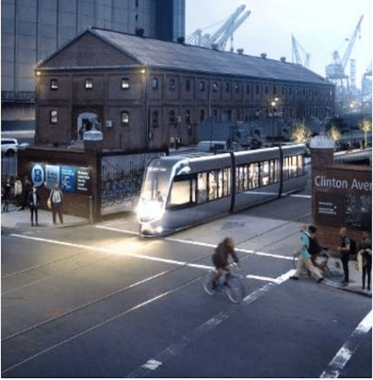

It’s been at least six decades since you could hop a streetcar and ride it from Queens to Brooklyn. That’s going to change.
On Tuesday, the Mayor’s Office released a report detailing possible routes for the BQX Connector streetcar line, which will run parallel to the Brooklyn-Queens waterfront, from Astoria, Queens all the way down to Sunset Park, Brooklyn.
The release, which was first reported by The New York Times, states that the 16-mile, $2.5 billion streetcar line will become operational by 2024. A series of “community visioning” sessions for the connector were held earlier this year, and another round of community meetings are slated for this Fall, the City said.
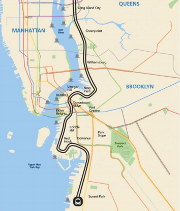
In Brooklyn, the connector will pass through — or near — Greenpoint, Williamsburg, Fort Greene, the Navy Yard, Vinegar Hill, DUMBO, Brooklyn Heights, Downtown Brooklyn, Cobble Hill, Gowanus, Red Hook and Sunset Park.
According to planners, the BQX will have 30 or more stops, approximately ½ mile apart. The line’s peak hour schedule is supposed to be 5-10 minutes between arrivals.
The price of a ride will be pegged to current MTA fares.
The goal is to have the BQX operate in street rights-of-way, with as much exclusive lane as possible, the City said. Stops are to be located in the center of the road — “blending into the streetscape.”
Planning for the Brooklyn (and Queens) of the Future
As always, the devil is in the details. Planners are now wrestling with the exact routes through Fort Greene, downtown Brooklyn, Red Hook and Sunset Park, for instance. Finalized routes will be announced early next year, the City said.
“After examining where people live, the location of public utilities and possible subway connections, city officials are considering moving the line farther from the waterfront than originally imagined in some locations,” the Times reported.
One also wonders whether concerns about rising sea levels and coastal storm surges could impact the final route.
“It’s become increasingly clear to us that there are places where moving it further inland makes sense,” Alicia Glen, Deputy Mayor for Housing and Economic Development, told the Times.
In Fort Greene/Clinton Hill, a Flushing Avenue route would be “closer to jobs and [the] growing Navy Yard,” while a Park Avenue route under the BQE would be “closer to existing housing,” planners noted.
Coming in to downtown Brooklyn, routes along Tillary and Willoughby Streets are both being weighed. Tillary offers “challenging intersections that connect to bridges and highways” but “less transit connectivity than other options.” While Willoughby provides “excellent subway connections to A/C/F/Q/R” subway lines but a “challenging connection to Downtown Brooklyn.”
In Red Hook, a route along Columbia Street is being compared to one on Van Brunt or Richards Streets. Columbia Street offers a “shorter running time [and] smaller geographic catchment area, but better serves [the] most densely populated part of Red Hook,” while Van Brunt or Richards Streets provide a “longer running time, but larger geographic catchment.”
Another question for the Red Hook section of the route is whether the BQX will cross the Gowanus Canal on a new bridge — at 10th or 19th Streets.
The BQX will terminate near the Brooklyn Army Terminal (around 58th Street near the waterfront) in Sunset Park.
In Sunset Park, planners are weighing routes along 4th Avenue (parallel to the R train); 3rd Avenue (the catchment area includes residential and industrial businesses but a “challenging street geometry” under the elevated expressway); and 2nd Avenue (“closer to center of industrial jobs” but the concentration of business loading/unloading could cause congestion issues).
Mayor’s Office Says Improving Transit Equity Is The Goal
The BQX will help address poor access to mass transit in growing waterfront areas, the City says, and the need for North-South transit connections, specifically. The new streetcar line represents a “shift from Manhattan-centric connectivity,” say planners, giving New Yorkers better access to “emerging” job hubs, and academic and cultural institutions in Brooklyn and Queens waterfront neighborhoods.
The area served by the BQX Connector is home to roughly 300,000 workers and 400,000 residents, the City says, including 40,000 NYCHA residents across 13 developments. Over half of the BQX catchment area’s rental stock is “public, rent-stabilized, rent-controlled, or income-restricted.”
Depending on its final route, the BQX has the potential to provide access to 10 ferry stops, 30+ different bus routes, 15+ different subway lines, and 100+ CitiBike stations, the City noted.


