City Releases New Evacuation Zone Map, Adding 600,000 People

Mayor Michael Bloomberg’s administration released a new evacuation map on Tuesday, creating a more zone system and adding 600,000 additional people to evacuation areas.
The new maps create zones numbered one through six, replacing Zones A, B and C, offering city officials more leeway in ordering specific areas to evacuate in the face of an oncoming storm and tidal surge. As many as 2,990,000 residents citywide now live in the zones – a number larger than the entire population of Brooklyn, the city’s largest borough.
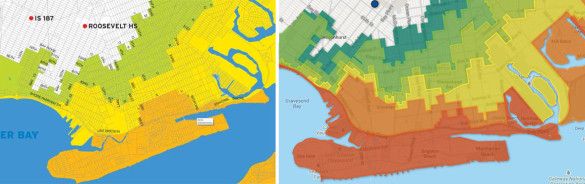
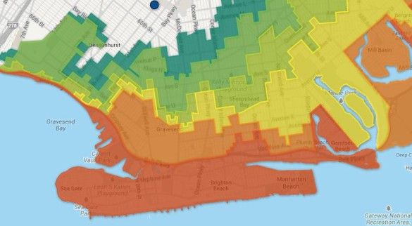
Most notable, some parts of the zones extend further inland in Brooklyn and Queens, and sees areas like Gerritsen Beach – previously a secondary evacuation zone – bumped up to a primary area after it experienced extensive flooding during Superstorm Sandy.
In the new system, Zone 1 is the most vulnerable to flooding. In addition to Gerritsen Beach, Coney Island, the Rockaways, Brighton Beach, Manhattan Beach and all of Sheepshead Bay south of the Belt Parkway are Zone 1.
Furthermore, the new zones include the addition of 26 Housing Authority developments, four hospitals and nine nursing homes. The administration was battered by critics after Sandy for not evacuating hospitals and nursing homes, and also for poorly responding to the needs of residents living in Housing Authority facilities.
Comparing it to the old map, it appears Zone 1, the primary evacuation zone, shrank in some areas compared to Zone A, and expanded in others. The old maps included a swath of Sheepshead Bay, from approximately Bedford Avenue to Ocean Parkway, up to Avenue X in the north, as Zone A. That’s been divided up between Zone 1 and 2. Elsewhere, including Gerritsen Beach, Mill Basin, parts of Bath Beach and the Canarsie coastline have been swapped from Zone B to Zone 1, reflecting the extent of Sandy’s flooding.
In fact, it appears that Zone 1 is based almost directly on the lines of where major flooding occurred during Sandy.
The new map and current evacuation orders can be seen here.
Do you live on a block that flooded during Sandy, but is not in Zone 1? Do you think you should be in Zone 1, or in a different zone than where you are? Let us know in the comments.