
BusTime Is Now Available In Brooklyn
THE COMMUTE: BusTime, already available on all bus routes in Manhattan, the Bronx, and Staten Island, has been expanded to all bus routes in Brooklyn as of Saturday. Previously in Brooklyn, it had only been available for the B61 and B63 bus routes. The expansion throughout Brooklyn and Queens, originally scheduled for 2013, was revised to March 9, 2014 according to an MTA press release, but was actually available a day early.
Signs, however, announcing the expansion to every borough already began appearing in several subway stations as early as February 24th. Leave it to the MTA to cause unnecessary confusion, even if it was only for two weeks.
What Is BusTime?
We’ve discussed BusTime several times before. It is a bus tracking system advising passengers where the next bus is so they would no longer have to rely on schedules, which are mostly not adhered to. Originally intended to be digital displays, either stand alone or built into the bus shelter, showing the arrival of the next bus, the MTA opted for a different system. A system that is only available to computer and smartphone users and those who know how to send text messages on a cell phone. Yes, that is most of the population, but does not include many seniors who are not tech savvy.
To make matters worse, the initial plan to show where buses are in real time has been changed to show how many stops away buses are or how many miles away they are. That is less useful. The major reason for the change is that the MTA did not want to pay a fee to a NextBus, a division of Cubic, which uses a proprietary algorithm to display estimated arrival times in minutes.
Why couldn’t our bus shelters also provide this information and why couldn’t advertisements alternating with schedules pay for their installation and maintenance? If advertisers could not be found at low usage locations, those stops could be packaged with very high usage locations, or in a worst case scenario only be provided on heavily utilized routes. It would still be better than only providing schedule information on poles, which is difficult to read in the dark.
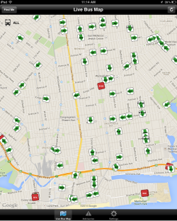
I do not want to give the impression that BusTime is completely useless. Knowing the number of stops away a bus is helpful, even though much of the time all you have to do is to look down the road several stops to see if a bus is coming. I find being able to view the location of the buses on a map to be more useful than knowing if a bus is 18 stops or three or seven miles away. How is the passenger supposed to know if a bus is traveling at four, eight, or 12 miles per hours? The passenger — especially someone in unfamiliar territory, on a route he or she does not normally take — has no such knowledge.
BusTime is still better than no information at all. In many cases, you will be able to meet the bus shortly before it arrives instead of waiting for it, which is the purpose of the system. But a subway countdown clock it is not. A display showing the next bus is five or seven miles away just means a very long time, and rather than encourage bus usage, it may have the opposite effect by causing someone to call for a cab instead.
A Long List Of Broken Promises
The decision not to provide the information at bus stops or in minutes, as was originally intended, is one of a long list of broken MTA and DOT promises. The current bus stop shelters were designed with a large ad space and a small space just above it for schedule information. That space now is just white space or sometimes it is used as additional advertisement space. The other white space was supposed to display up to date strip map information, which, unlike the Guide-a-Ride signs on the poles, are lit up at night.
CEMUSA decided they did not want to update the maps, so instead they started replacing them with Transit Tips. Then they decided that was too much work also, and now on most bus shelters it is also just white space. The DOT, which manages their contract, appears either to be negligent in enforcing it or quietly eliminated the provision requiring lit up bus numbers and strip maps. Of course, providing borough-wide maps on the shelters would be asking way too much, although Chicago sees fit to provide a complete transit map on all its bus shelters and also display arrival information in minutes.
A History Lesson
The MTA has been promising a bus locator system since prior to 1980. That year, a pilot bus locator system was installed at the newly-constructed Queens Village Depot in Southeast Queens. It was not GPS-based as is today’s system. It could only pinpoint buses within a quarter-mile, but, unlike the three failed GPS attempts over the following 30 years, one of which was priced at $14 million, the 1980 version worked. Instead of being expanded citywide as intended, it was removed due to pressure from the transit unions fearing Big Brother (coming in 1984) being able to keep watch over its bus operators. The MTA was fearful of a strike if it did not cave into union demands. It is doubtful if the unions of today could exert that type of influence.
So after 35 years of promises, we finally get Bus Time, though not as originally envisioned. However, if buses are delayed due to traffic, unusually heavy loadings, or some other reason, Bus Time still will not make the buses come any faster, or will it?
BusTrek
That brings us to BusTrek, a companion to BusTime, still in its pilot stage. It is already in use at least in Manhattan. Using information provided by BusTime, BusTrek should help dispatchers to make real time decisions to help keep buses operating on schedule and minimize bus bunching. Before BusTime, it was not possible to know where all the buses were on a given route at any one moment in time, making it difficult to make decisions that would reduce bus bunching.
The possibilities with BusTrek, I believe, are much more exciting and useful than merely telling passengers where buses are. A system that can reduce a 45-minute wait to 15 or 20 minutes has great potential. The MTA has thus far given no indication when the pilot will be completed and what will happen if it is not successful — whether they will abandon it or further attempt to make it work. One MTA employee let it be known on the Internet that some employees involved in the pilot have been using the technology to play video games rather than regulate the buses. I will not provide a link or reveal on which site I learned this, because knowing the MTA, rather than disciplining the employees involved, they would be more likely to discipline the employee who spilled the beans.
The other advantage of BusTime is that now, everyone will be able to see just how extensive bus bunching really is, and it’s not just me saying that one out of three buses arrive in a bunches much of the time.
The Commute is a weekly feature highlighting news and information about the city’s mass transit system and transportation infrastructure. It is written by Allan Rosen, a Manhattan Beach resident and former Director of MTA/NYC Transit Bus Planning (1981).
Disclaimer: The above is an opinion column and may not represent the thoughts or position of Sheepshead Bites. Based upon their expertise in their respective fields, our columnists are responsible for fact-checking their own work, and their submissions are edited only for length, grammar and clarity. If you would like to submit an opinion piece or become a regularly featured contributor, please e-mail nberke [at] sheepsheadbites [dot] com.


