
Big Plans For To Unite Coney Island Wetlands With Bath Beach’s Calvert Vaux Park
As Mayor Michael Bloomberg exits the stage, he is hoping a big part of his legacy will include the successful follow through on a $20 billion “resiliency” plan that would seek to protect the city’s coastlines from rising sea levels and future storms. The New York City Economic Development Corporation (NYCEDC) laid out one such plan that involves both beautifying and fortifying Coney Island Creek, through a plan that would unite Coney Island’s Kaiser Park with Bath Beach’s Calvert Vaux Park.
During the events of Superstorm Sandy, Coney Island Creek got hammered, suffering massive flooding and heavy damage. The NYCEDC described the damaged sustained to the area by the storm, the strategy to protect the area and how the proposals would improve the surrounding community:
During Hurricane Sandy, Coney Island Creek was the main source of inundation for much of the Gravesend and Coney Island neighborhoods. Low edges and topography contributed to “backdoor” flooding that caused enormous damage. Building off recommendations from the Mayor’s Special Initiative for Rebuilding and Resiliency (SIRR) released in June 2013, a key recommendation was a detailed feasibility study of integrated hydrological management strategies.
These strategies would prevent and mitigate upland flooding in adjacent areas while improving waterfront open space, strengthening connections between neighborhoods, and establishing principles for sound development around the Creek. This assessment would consider technical feasibility, cost, phasing, environmental considerations, and other important issues that will inform implementation.
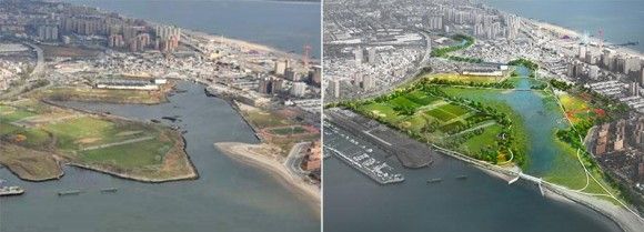
The city’s website broke down the specifics of these plans even further as well as what the project needs going forward to become a reality:
The proposal for Coney Creek includes:
- Coastal Protection: The installation of a new levee and tidal barrier system at the mouth of the creek to manage the flow of water during a similar future coastal storm. As a first phase, the City intends to install shoreline protection along the creek’s lowest lying edges to provide interim protection in advance of a larger investment.
- Stormwater Management: By incorporating operational controls to the City’s stormwater management system, this system would allow the creek to absorb stormwater runoff and improve drainage to protect adjacent neighborhoods and infrastructure during coastal storms or extreme precipitation events.
- Parks: By combining Calvert Vaux and Kaiser parks around a renewed and restored wetland and lake complex, this system can bring together two neighborhoods historically separated by Coney Island Creek and achieve better waterfront access and a new destination park in Southern Brooklyn.
Next steps: A portion of the City’s Community Development Block Grant funding has been allocated for the planning of this project. An RFP is currently being developed for a team to develop the concept further and provide critical information about technical, environmental and planning issues as well as costs.
The whole concept sounds fantastic and expensive but no one said storm proofing the New York City coastline was going to be easy or cheap. I suppose forking over a lot now might prevent being forced to pay a ton later when the city is engulfed by ocean waters.


