
Dangerous Intersections – Don’t Let One Way Streets Fool You

Roughly 40 percent of the city’s intersections have one-way streets and Localize.city looked at where the most pedestrians and cyclists were injured in these types of intersections between January 2013 and January 2018.
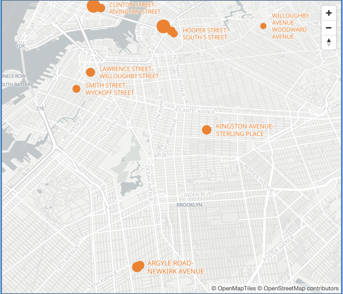
While local streets tend to have less traffic and fewer overall crashes, the 20 most dangerous intersections had on average one crash every 9 months, and the intersections tend to be clustered. Most one-lane intersections saw almost no crashes injuring a pedestrian or cyclist over 5 years, their data team reports. Eight out of the 20 most dangerous intersections are in Brooklyn.
Ditmas Park:
- Newkirk Avenue and Argyle Road (4 injured pedestrians, 3 injured cyclists)
- Newkirk Avenue and Rugby Road (4 injured pedestrians, 2 injured cyclists)
Williamsburg:
- South Fourth and Keap streets, (2 injured pedestrians, 5 injured cyclists)
- South Third and Havemeyer streets (4 injured pedestrian, 7 injured cyclists)
- Hooper and South Fifth streets (2 injured pedestrians, 4 injured cyclists)
Crown Heights
- Sterling Place and Kingston Avenue (5 injured pedestrians, 2 injured cyclists)
Downtown Brooklyn
- Lawrence and Willoughby streets (5 injured pedestrians, 2 injured cyclists)
Boerum Hill
- Smith and Wycoff streets (2 injured pedestrians, 4 injured cyclists)
“A lot of attention has been given to dangerous large avenues and thoroughfares in recent years — and rightly so. But remember that dangerous driving can, and does, still happen on quiet neighborhood streets,” said Localize.city urban planner Alon Goldstein.
In Ditmas Park, two consecutive intersections on Newkirk Avenue — at Argyle Road and at Rugby Road — were hot spots, with a total 13 pedestrians and cyclists injured within the five-year time frame.
Neighbors in Ditmas Park have been requesting traffic safety measures along Newkirk Avenue stretch from East 16th street to Coney Island Avenue for years, only to be told they don’t meet the criteria.
There is no stop sign on Newkirk Avenue at Argyle Road (which heads north allowing cars to avoid Coney Island Avenue during morning rush hours), and cars make fast left turns there, often without yielding to pedestrians, some residents have complained. For drivers, the angle of the streets makes getting a clear sight line are challenging, forcing cars into the crosswalk. The local elementary school P.S. 217 is just one short block away, there is a medical facility between the two intersections and a busy subway stop another block away.
In Williamsburg’s cluster of dangerous one-lane intersections on either side of the Williamsburg Bridge, the majority of the 24 people injured were cyclists, unlike in the other neighborhoods, Localize.city reports. Sixteen cyclists were injured over five years within a few blocks of one another.
“The DOT completed several iterations of safety upgrades around the Williamsburg Bridge, but crashes have continued even after some recent changes. The DOT was continuing to focus on improving safety in advance of the planned L train shutdown. It’s unclear what will happen to some of those street safety upgrades as the L train project remains in flux. Even with a partial shutdown on nights and weekends, locals are worried about more chaos in the area as additional bicyclists, buses and others scramble to get from Brooklyn to Manhattan,” authors of the report note.
Kingston Avenue and Sterling Place in Crown Heights is another crash prone location, despite the addition of bike lanes to calm traffic, with at least one crash injuring pedestrians or cyclists every year since 2013.
“Over the past five years, nearly 8 percent of pedestrian and cyclist injuries or fatalities caused by traffic crashes occurred in single-lane intersections,” Localize.city data scientist Israel Schwartz said. “These intersections can be troublesome to those traversing them on a daily basis.”
When asked for plans for these intersections to improve the chances of pedestrians and bicyclists making it across safely, the NYC Department of Transportation spokesperson said that “DOT takes each crash seriously and is continuously looking for new solutions to help eliminate traffic-related injuries and deaths. We do recognize that overall fatalities are up for January 2019 compared to January 2018 and we are monitoring trends closely. With those trends in mind, DOT will soon release Vision Zero Borough Pedestrian Safety Action Plans, updated for the first times since 2015, which will refocus where we target our interventions, safety engineering, enforcement action, and education initiatives.”
“New York City needs to be redesigning all of its streets to comply with a Vision Zero design standard so people are safe getting where they need to go, whether they are on foot, on bike or in a vehicle,” said Thomas DeVito, senior director of advocacy at Transportation Alternatives.
“This means dramatically expanding the implementation of curb extensions; daylighting every intersection; further automating enforcement against speeding, illegal parking, and right of way violations; as well as building out a comprehensive protected bike lane network. We know how to design streets so no one is killed in traffic, we need the courage to do it.”
Updated at 5:30 pm to include response from NYC DOT.


