How to Plan for Bike Lanes in Community District 14
If you do, or don’t, want to see more designated bike routes in Ditmas Park and surrounding areas, you need to tell Community Board 14. At the CB14 Transportation Committee meeting last night, a representative from the Department of Transportation laid out the process, and it literally starts with you, the residents of the community.
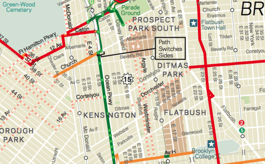
Hayes Lord, director of the Bicycle Program at the DOT, began his presentation by showing a section of the 1997 Bicycle Master Plan. The map above shows established lanes in solid colors, and the dotted lines represent streets that the DOT considered as potential bike routes back when they looked at them around 1995.
Because neighbors have expressed interest in moving ahead with more bike routes, he said these potential routes should be considered, but the DOT needs input on what might or might not work.
“A lot has probably changed over the past decade-plus,” Hayes said. “Plus, there may be new areas of cycling interest.”
One route he noted will be added this summer is along Ocean Avenue, from Parkside to Avenue H. It will be a shared lane, like the one along Avenue H, where “sharrows” are painted in a driving lane to let drivers know that cyclists may be using the road there as well. Most people at the meeting were doubtful about how helpful that will be on a stretch like that, where double parking is rampant — which woud obstruct that shared lane.
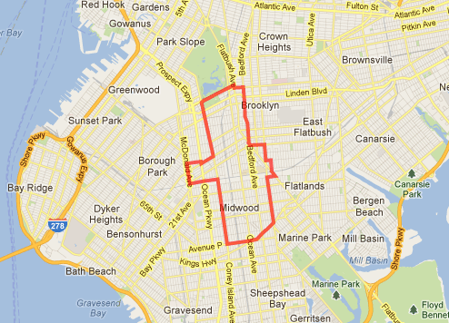
This is the area that you should consider when thinking about potential bike routes — these are the borders of our Community District 14. Other things to keep in mind:
• If you think a particular road would be good, and it’s a one-way street, what is the companion street where traffic goes the other way that could have another bike route?
• The idea is to create a network of routes, so the new routes should, if possible, connect to existing ones.
• Be specific about streets and what the limits should be. For instance, “Dorchester Road from Flatbush to Coney Island Avenue.”
These are the very early stages of planning. Once CB14 presents possible routes to the DOT, then the DOT will evaluate those routes, and will come back to CB14 with plans, at which point the Community Board can decide whether or not they support the plans.
Got some suggestions? Do you support bike routes in the area? Let CB14 know by emailing them at info@cb14brooklyn.com.

