Four Years After Sandy, Climate Resiliency Planning For Brooklyn Waterfront Continues


In recognition of the fourth anniversary of Superstorm Sandy, we’re taking a deeper look this week at the status of recovery efforts along the Brooklyn waterfront. We’re also trying to understand how the City is working to protect coastal communities from rising seas and the storms of the future.
Building on the work of Mayor Michael Bloomberg, the de Blasio administration says that it is undertaking coastal defense and climate resiliency measures “in some of the most vulnerable communities across the city.”
Brooklyn waterfront neighborhoods like Fort Greene, Gowanus, Red Hook and Sunset Park clearly fall into this category. The vulnerabilities of the Brooklyn/Queens waterfront were highlighted by Sandy, the City noted in a detailed 2013 analysis.
“Although the Waterfront’s sheltered location in New York Harbor largely protected the area from destructive waves, the storm’s surge did cause extensive flooding throughout the area—in many places over 6 feet deep.
Not surprisingly, flooding occurred along the Harbor and River-facing western edge of the Waterfront, inundating neighborhoods, industrial properties, and retail corridors. The surge also made its way up the Gowanus Canal and Newtown Creek, flooding areas much farther inland.
The result of this deluge was damage to building systems and contents, loss of power, displacement of residents, and weeks to months of lost revenue for businesses and nonprofits.”
On the Brooklyn and Queens waterfront, over 1,300 residential buildings, containing nearly 16,200 residential units, were within Sandy’s inundation area, the City said. Likewise, over 3,000 waterfront businesses, employing some 34,600 people, were directly impacted by the storm.
Flooding also overwhelmed the city’s sewers in many places, resulting in sewage backing up into homes and businesses, as well as combined sewer overflows into local waterways, the City noted.
Sandy had a severe impact on some of our most vulnerable coastal residents. Several thousand tenants in the Red Hook Houses, Brooklyn’s largest public housing development, lost power, heat and hot water for weeks after boilers and generators were flooded out by Sandy’s storm surge.
Preparing for Rising Seas & Storm Surges
Protecting the Brooklyn waterfront from the future impacts of climate change is urgent — an analysis published by the City’s scientists last year found that since 1900, New York City has seen sea levels rise around 12 inches—nearly twice the observed global rate over a similar time period.
This trend is expected to continue, and even accelerate, as the 21st century progresses. According to the City’s report, area sea level could rise 11 to 21 inches by the 2050s.
The de Blasio administration has created a “citywide resiliency map,” which it says shows the status of every project in the City’s $20 billion climate resiliency program — OneNYC. You can use the map to get basic details about projects, such as cost, estimated date of completion, and the managing agency.

The Decision Not To Retreat From The Coastline
In the aftermath of Sandy, the Bloomberg administration made an overarching decision not to retreat from the city’s coastline. The de Blasio administration has essentially continued this policy.
To some extent, the City is planning to protect the waterfront using “natural” means, such as “green infrastructure” like bioswales and permeable paving in order to absorb coastal flooding. The City is also “hardening” critical infrastructure and elevating building mechanical systems when possible, in anticipation of flooding.
But the City is also planning some larger-scale flood protection projects along the waterfront, for Red Hook and possibly Gowanus.
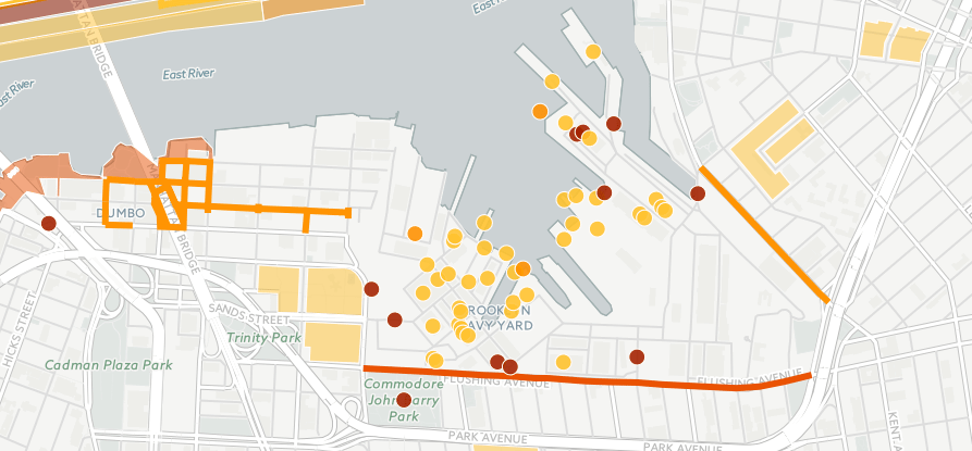
Below, we highlight just some of the projects currently underway (or completed) along the waterfront between Fort Greene and Sunset Park. Note that both the dots, and dark lines, on the City’s map represent projects.
The list below does not include, for example, an $8 million planning study underway for neighborhood-specific strategies — including zoning and land use changes — in flood zones across the city.
1.) Brooklyn Navy Yard/Fort Greene/DUMBO. Below, you can see the multitude of resiliency projects in the Brooklyn Navy Yard — such as repairing and fortifying piers, electrical substations and transformers, and pump houses.
The dark orange line on Flushing Avenue indicates a bike path, sidewalk extension, and pavement improvements for the Brooklyn Greenway, which is seen as helping to make the coastline more sustainable and resilient.
Up to the left, in DUMBO, new water mains, combined sewers, and storm sewers are to be built at a projected cost of $35 million.

2.) More work is being done to protect Brooklyn Bridge Park and DUMBO. Projects include creating additional “rip rap” edges to reduce the impact of wave action, and selecting soils and plant material for future park phases. Total cost $13 million (privately funded)
3.) Integrated Flood Protection System for Red Hook. This coastal flood “risk reduction” system is being planned to help protect sections of Red Hook along the Buttermilk and Red Hook channels and outer Gowanus Canal (see map below).
The flood protection system could include a natural greenway, deployable flood walls, elevated streets and drainage pumps. The City said it issued “requests for proposals” for the project last year, and held a series of public meetings (the most recent one was in October) on its plans this year.
The City and State have committed a total of $100 million to be used for environmental review, permitting, design, engineering, and construction work on the project.
Also of note, the deep orange line on Van Brunt Street below represents funding for community based development organizations to “implement commercial revitalization activities” after Sandy. The Red Hook Houses appear in orange nearby.

4.) Thirty-three NYCHA developments — including Red Hook East and West and the Gowanus Houses — were collectively awarded $3 billion in FEMA funding last year. The funds will assist NYCHA in making the 33 developments more resilient to future storms and extreme weather. This includes new construction of elevated boilers, installation of flood barrier systems, and acquisition of stand-by generators.
The money is also supposed to go toward critical repairs needed after Sandy’s storm surge flooded basements and first floors, severely damaging boilers and electrical and mechanical equipment.
5.) Resiliency projects are also being planned for the Gowanus Canal.
The dark orange dot at the bottom of the Canal indicates a study evaluating a possible storm surge barrier to protect nearby properties and infrastructure from coastal storms. (A similar study is being conducted in Newtown Creek.)
The dot at 9th Street indicates that the mechanical and electrical systems of the bridge there are being repaired and flood proofed. Eleven other moveable bridges in the city are being similarly flood proofed.
The dark orange and lighter orange grids show two phases of planned “high level” storm sewer installation and water main replacement.

6.) In Sunset Park, below, the City is planning to install flood barriers at the Brooklyn Army Terminal, and elevate the electrical substation at Bush Terminal. Total cost $21 million.
On the eastern side of 3rd Avenue, one of 51 “critical” schools across the city will have an “Emergency Power” system installed. The total cost for all 51 schools is $14 million.
The orange line below represents the Owl’s Head Connector section of the Brooklyn Greenway. Plans for this section of the Greenway include street reconstruction, along with work on a bicycle path, existing parking, seating, and resting areas.

What About Single Family and Small Residential Buildings?
One of the biggest question marks in the City’s plans is whether owners of single-family and small residential buildings, located in flood zones, will be able to afford to elevate their homes, or take other steps to prepare for rising sea levels.
The City’s mixed record in helping private homeowners rebuild and/or renovate after Sandy will color public perception of its resiliency projects for the foreseeable future. Earlier this year, Mayor de Blasio said the City would complete its highly fraught Build It Back program by the end of 2016, but since then has stated that the City cannot meet its own deadline and requires an additional half-billion dollars.
According to a 2016 progress report issued by the City, the Build it Back Single Family program has started construction on over 2,600 homes across the five boroughs, completed construction on over 1,500 homes, and distributed 100 percent of reimbursement checks, amounting to over $110 million. Through its Multi-Family program, the City says it has provided assistance to 87 multifamily buildings, or roughly 12,600 households.
What Do You Think?
What do you think about the City’s resiliency projects Brooklyn? What is needed to protect our communities from the impacts of climate change?
What can you tell us about your experience with Build It Back?


