
Winter Snow Showers Are Coming Tonight Into Wednesday; Wind Advisory Is In Effect

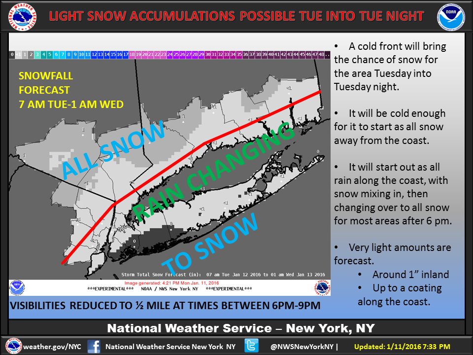

This morning’s cold temps have warmed up a bit, so the previously forecast snow may become snow showers, according to the National Weather Service (NWS), which released these forecast maps today.
“A quick moving area of low pressure over the Great Lakes will send a cold front toward the area Tuesday into Tuesday night. It will be cold enough for all snow inland and rain along the coast,” they wrote on Facebook. “The rain will mix with and change over to all snow for most areas after 6 pm. Only light accumulations are expected…around 1″ inland and a coating along the coast. Visibilities may be reduced to 1/2 at times between 6 pm and 9 pm, so be careful if driving!”
A wind advisory has also been issued for the city, beginning tonight at 8pm and running through 1pm tomorrow (Wednesday, January 13). The NWS warns of sustained winds of 10-20mph with gusts up to 50mph possible.
During periods of high winds, residents should use caution when walking or driving high profile vehicles. Winds at these speeds can cause flying debris, turn unsecured objects into projectiles, and cause power outages.
To prepare, charge cell phone batteries, gather supplies, and turn refrigerators and freezers to a colder setting. Always stay clear of downed power lines. If you are affected by an outage, turn off all appliances and keep refrigerator and freezer doors closed to prevent food spoilage. Do not use generators indoors. If you lose power and have a disability or access needs, or use Life Sustaining Equipment (LSE) and need immediate assistance, please dial 9-1-1. For the latest weather information visit www.weather.gov/nyc.


