
The Most Beautiful Old Brooklyn Maps

I’m a sucker for a beautiful map. Lucky for us, our city, borough and neighborhood are featured on many gorgeous old sheets of paper.
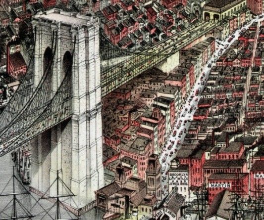
The City of Brooklyn, by Currier & Ives, 1879
Possibly the most beautiful map of Brooklyn ever made. The size and detail sucks you in. You should go to the map, zoom in and get lost. Beyond the mountainous Brooklyn Bridge (pictured above) and the Borough of Church’s namesakes, you can spot the then-new Prospect Park by the blue lake and tall trees it holds. It would have to be saved from development in just a couple of decades. The spire from the Flatbush Dutch Reformed Church towers above the green as trains move through our own very green neighborhood on newly built railroads built for a growing metro area. A less detailed but more brightly colored version (closer to the original in that regard) can be seen here.
Prospect Park, by Olmsted, Vaux & Co, 1871
This map (which we covered here) is a beautifully colored and provocatively tactile piece of work. Better yet, it gives us insight into what our area was like in the 19th century: important roads and areas with different names plus huge tracts of land to the east of the park for sale that would become the Botanic Gardens.
Brooklyn City Railroad Map, 1874
Want to get to Coney Island? Easy, just hop on the railroad. Of course, the train only runs a little south of Prospect Park, so you’ll have to stay a night in the Hotel Oak (or someplace else, depending on what year you’re in) before hitching a ride on the trolleys early to see the beach but be careful — it’s always been a dangerous street.
In July 1868, The New York Times decried the scourge of ruffians who preyed on day-trippers coming back from the beaches. ”Only last Sunday,” The Times wrote, ”a car on the Coney Island road was taken possession of on its return trip by a number of pickpockets, a fight extemporized and the car thrown from the track and upset. During the confusion the respectable passengers were relieved of their valuables.”
BMT Route and Places of Interests, by World’s Fair, 1939
Somewhere in between the early-modern subway maps and our own, this World’s Fair map is a novelty. Look at all the places you can visit in New York: The Empire State Building, The World’s Fair and, hey, why not go to Brooklyn College as well?
Subway Map, New York Telephone, 1951
This map is closer to modernity but still foreign looking to most of our eyes. Subway maps from all over the world are really gorgeous things: so much information about past lives in such a small, colorful little package. Check out how easy it was for our neighbors to make the trip to Ebbets Field!
One more modern classic worth mentioning is the MTA’s 1974 subway map, the epitome of that old art cliche: unappreciated in its own time and aged into a masterpiece.
If you’re interested in seeing more maps, you can visit the Brooklyn Historical Society during the library’s open hours Wednesday through Friday from 1 to 5 p.m.
Do you have any favorite maps of the neighborhood, borough or city?


