
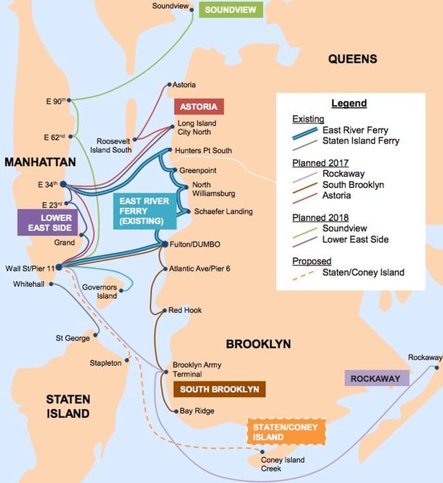
Map: How De Blasio’s Expanded Ferry System Will Connect The Boroughs


Local elected officials praised Mayor Bill de Blasio’s $55 million plan to expand the city’s ferry system – including stops in Bay Ridge, Sunset Park, Red Hook, and Brooklyn Army Terminal – which will provide fast access between all five boroughs for the fare of a MetroCard by 2017.
“Today I applaud Mayor de Blasio for his $55 million capital commitment to a 5-borough ferry system and declaring that New York City’s waterfront will be open for all. The ripple effect from this service will be felt throughout the entire city from Bay Ridge to Bayside; from Staten Island to Soundview,” said Councilman Vincent Gentile in a statement yesterday. “Access to a true 5-borough ferry system will be just another jewel to add to our crown here in southwest Brooklyn, one that will be a boon to small businesses and real estate alike.”
Property values around ferry stops are expected to increase by 8%, according to data from 2013 study of the ferry service by the New York City Economic Development Corporation. In addition, proposals are underway to eventually add ports in Coney Island and Stapleton, dramatically increasing access between Southern Brooklyn and Staten Island.
Carlo A. Scissura, President and CEO of the Brooklyn Chamber of Commerce, also praised the plan, saying it would aid Southern Brooklyn commuters and would boost economic development, job growth, and housing in the area.
“The Brooklyn Chamber has been calling for a South Brooklyn ferry route for over two years, and Mayor de Blasio has gone above and beyond with this plan. I want to thank and congratulate the Mayor for his proposal, and I look forward to riding the waves along Southern Brooklyn soon,” Scissura said.
The project will cost the city $55 million to build the infrastructure, and between $10 million and $20 million annually to subsidize the service for 4.6 million riders, which would actually be run by private companies.
Gothamist created this map highlighting just how interconnected the boroughs will be when the plan is complete:
Proposed NYC Ferry Expansion Map


