
Four Years After Sandy, Climate Resiliency Planning For South Brooklyn Continues


In recognition of the fourth anniversary of Superstorm Sandy, we’re taking a deeper look this week at the status of recovery efforts along the Brooklyn waterfront and in Southern Brooklyn. We’re also trying to understand how the City is working to protect communities in these areas from rising seas and the storms of the future.
Building on the work of Mayor Michael Bloomberg, the de Blasio administration says that it is undertaking coastal defense and climate resiliency measures “in some of the most vulnerable communities across the city.”
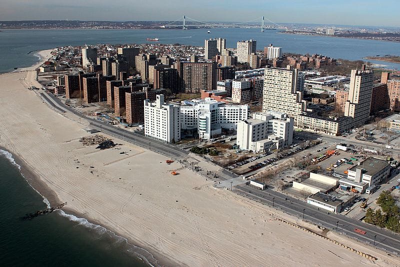
The neighborhoods of Southern Brooklyn (Coney Island, Sheepshead Bay, Brighton Beach, Gerritsen Beach, Gravesend, Manhattan Beach and Sea Gate) clearly fall into this category. Sandy’s storm surge struck Southern Brooklyn from different directions, the City noted in a detailed 2013 analysis.
“The storm brought direct wave impacts northward, with water traveling 1.5 miles north to Avenue W, joining floodwaters from Sheepshead Bay and Coney Island Creek…
The swelling of Coney Island Creek, too, led to inundation in Coney Island and Gravesend. The surge overtopped the creek’s low edges (in fact, there was flooding along Neptune Avenue, adjacent to Coney Island Creek, a full 12 hours before the surge’s peak).
Even in the ocean-facing neighborhoods of Coney Island, Brighton Beach, and Manhattan Beach, flood waters came primarily from their “backdoors” until the peak of the storm when, in many areas, waters from the ocean met waters from the north side of the peninsula on land.”
Sandy-related flooding had a “huge impact” on the homes and residents of Southern Brooklyn, the City reported. Restoring electrical, heat, and elevator systems in high-rise buildings— including public housing and Mitchell-Lama buildings—took two to four weeks and, in some cases, even longer.
Interestingly, the storm’s impact on area buildings was “primarily from stillwater flooding,” the City said. “Inundation damaged ground-floor and basement spaces, destroying electrical equipment and other building systems, and disrupting power service. Thousands of commercial spaces were inundated, resulting in the loss of inventory and valuable equipment that was not elevated.”
City Says “Build It Back” Program Will Not Be Completed By Year’s End
The City’s mixed record in helping private homeowners rebuild and/or renovate after Sandy will color public perception of its resiliency projects for the foreseeable future. Earlier this year, Mayor de Blasio said the City would complete its highly fraught Build It Back program by the end of 2016, but since then has stated that the City cannot meet its own deadline and requires an additional half-billion dollars.
According to a 2016 progress report issued by the City, the Build it Back Single Family program has started construction on over 2,600 homes across the five boroughs, completed construction on over 1,500 homes, and distributed 100 percent of reimbursement checks, amounting to over $110 million. Through its Multi-Family program, the City says BIB has provided $45 million in repairs, reimbursements and resiliency assistance to 87 multifamily buildings, or roughly 12,600 households.
Preparing for Rising Seas & Storm Surges
Protecting Coney Island, Bensonhurst and Gravesend from the future impacts of climate change is urgent — an analysis published by the City’s scientists last year found that since 1900, New York City has seen sea levels rise around 12 inches—nearly twice the observed global rate over a similar time period.
This trend is expected to continue, and even accelerate, as the 21st century progresses. According to the City’s report, area sea level could rise 11 to 21 inches by the 2050s.
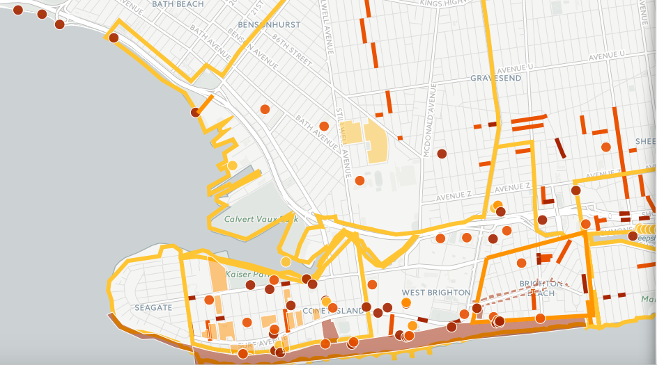
The de Blasio administration has created a “citywide resiliency map,” which it says shows the status of every project in the City’s $20 billion climate resiliency program — OneNYC. You can use the map to get basic details about projects, such as cost, estimated date of completion, and the managing agency.
The Decision Not To Retreat From The Coastline
In the aftermath of Sandy, the Bloomberg administration made an overarching decision not to retreat from the city’s coastline. The de Blasio administration has essentially continued this policy.
In a nutshell, it would appear that the City is planning to protect Southern Brooklyn using mainly “natural” means, such as replenished beaches and “green infrastructure” like bioswales, permeable paving and possibly restored wetlands, in order to take the edge off storm surges. The City is also “hardening” critical infrastructure and elevating building mechanical systems when possible, in anticipation of flooding.
One of the biggest question marks in this plan is whether owners of single-family and small residential buildings, located in flood zones, will be able to afford to elevate their homes, or take other steps to prepare for rising sea levels.
Resiliency Projects Of Note
Below are ten of the projects currently underway (or completed) in the Coney Island, Bensonhurst, Gravesend area. Note that both the dots, and dark lines, on the City’s map represent projects.
It is important to stress that these are just some of the projects the City is currently working on. The list below does not include the $7 million spent on beach replenishment in Coney Island and Sheepshead Bay, along with an $8 million planning study underway for neighborhood-specific strategies — including zoning and land use changes — in flood zones across the city.
1.) Thirty-three NYCHA developments — including Coney Island Houses, Carey Gardens, Surfside Gardens, O’Dwyer Gardens, Haber Houses and Gravesend Houses — were collectively awarded $3 billion in FEMA funding last year. The funds will assist NYCHA in making the 33 developments more resilient to future storms and extreme weather. This includes new construction of elevated boilers, installation of flood barrier systems, and acquisition of stand-by generators.
The money is also supposed to go toward critical repairs needed after Sandy’s storm surge flooded basements and first floors, severely damaging boilers and electrical and mechanical equipment, and leaving many residents without power and heat.
2.) Green Infrastructure implementation for flood control. [Multisite, extending along the Southern Brooklyn coastline, from Bath Beach all the way to Canarsie.]
Total cost $13 million for City Council districts 28, 31, 32, 43, 46, 47 and 48.
3.) Emergency bulkhead repairs at various locations along the Belt Parkway for “coastal defense.” [Multisite] Total cost $10 million. COMPLETED.
4.) Coney Island Creek Wetlands and Tidal Barrier Study investigating “short and long-term hydrological management strategies to mitigate upland flooding, while also improving waterfront open spaces, neighborhood connections, and economic development opportunities.”
Total cost $1 million
5.) Replacement of mechanical and electrical systems above flood elevation in City Parks facilities in Coney Island and Manhattan Beach. [Multisite]
Total cost $12 million for City Council districts 47, 48, and 50. COMPLETED.
6.) Vocational resiliency training in Community Board 13 — includes workforce training through Career Technical Education schools.
Total cost $750,000
7.) School Recovery & Resiliency at K188. Work includes heating plant, fire alarm replacement, interior spaces, ventilation/ductwork, electrical systems, and flood elimination.
Total cost $19 million
8.) Installation of 35 new pre-fabricated modular building units in Brooklyn, Queens and Staten Island by the Parks Department for “coastal defense.” Two of the units are located on the beach between West 10th Street and the Aquatheater.
Total cost for all 35 units — $124 million.
9.) Coney Island Library Mitigation. Work includes hazard mitigation against future storms for the library, which was severely impacted by Superstorm Sandy.
Total cost $1 million
10.) Restoration of four Brooklyn Public Library branches impacted by Sandy: Gravesend, Brighton Beach, Sheepshead Bay and Red Hook.
Total cost $4 million. COMPLETED.
What Do You Think?
What do you think about the City’s resiliency projects in Southern Brooklyn? What is needed to protect our communities from the impacts of climate change?
What can you tell us about your experience with Build It Back?


