
Finding A Safer Traffic Solution For 20th Street

“We don’t have any agenda except to make our street safer,” said 20th Street resident Miriam at a meeting on Tuesday night with the Department of Transportation, Community Board 7, and Community Board 14 — and it was a sentiment echoed by everyone in attendance.
With sleet falling outside, it was a fairly small turnout for the meeting at the Windsor Terrace Library, which is right around the midpoint of the areas the 20th Street Truck Route Area Study is looking at. Following a petition signed by more that 200 20th Street residents in 2010 citing property damage, congestion, and additional safety issues, the DOT launched the study to see if the truck route along that road might be altered to improve the situation.
“The issue on 20th Street is no so much that vehicles are being hit — it’s a safety issue for pedestrians,” said Miriam, her young son in tow. “For instance if you’re getting into your car, people’s doors have come off, people have been nudged into their cars. Because it’s a bit wild, people drive with a lot of bravado and crossing the street is quite difficult and scary.”
The study — which so far has involved analyzing land use and traffic and crash data, interviews with truck drivers on the street, arial surveys, and more — continues, and this meeting will be just one of more to come throughout the affected communities, because the issue is a fairly complicated one.
“We don’t have a solution yet that jumps out and says, ‘That’s the answer,'” said Stacey Hodge, director of the Office of Freight Mobility at the DOT.

That’s because it’s not as simple as switching 20th Street, which is part of the city’s truck route system and is currently a narrow, two-way road with parking allowed on both sides and slim, often battered sidewalks, into a one-way road. There would need to be a corresponding one-way truck route stretch nearby; where those trucks are headed needs to be considered; they need to make sure there aren’t three streets in a row that all go in the same direction; bus routes could be altered; potential increased truck traffic near schools needs to be looked at; among many other things.
So far their study has revealed some basic insights that will impact future decisions about any changes. For instance, they found that most trucks traveling on 20th Street are making local deliveries, rather than using it as a through-route to someplace further away, and between 65-75% of trucks using 20th, both in the morning and in the evening, are headed eastbound.
One issue that heavy eastbound traffic creates in the Kensington and Ditmas Park areas is trucks avoiding the through-truck route of Church Avenue and opting for the local-truck route of Caton Avenue — which, if they’re one of that portion that’s not making local deliveries, is illegal. But it’s not just enforcement that’s at fault here, it’s also design. Trucks coming from 20th Street/McDonald Avenue get to Caton first, so they’re naturally more likely to turn there rather than wait for Church, and left-hand turns onto Church are not allowed from the Prospect Expressway — and that’s not likely to change any time soon.
“Church Avenue is the first signal you hit. You’re on an expressway and the speed limit’s 45, but people go a lot faster, and you have to slow them down to 30 for Ocean Parkway,” explained Greg Haas, a city planner at the DOT. “If there’s a left turn permitted [it will dangerously back up traffic]. And there’s no room for a left-turn bay. We just recently made the median as a refuge on the north crosswalk — it would basically eliminate the north crosswalk if we put a left-turn bay there, but there’s not enough room to do it, anyway.”
Still, enforcement may be increased going forward — or at least that’s the hope of the city. As part of this study, the DOT has been working with NYPD and state enforcement to stop trucks in this area, and while the police inspect the vehicles, the DOT has interviewed the drivers. Some of those stops resulted in tickets and even taking the trucks out of commission.
“We want to keep doing this,” said Hodge. “Because this year Vision Zero is really going to be focusing on trucks, so we have a commitment to continue to do this — in other boroughs too.”
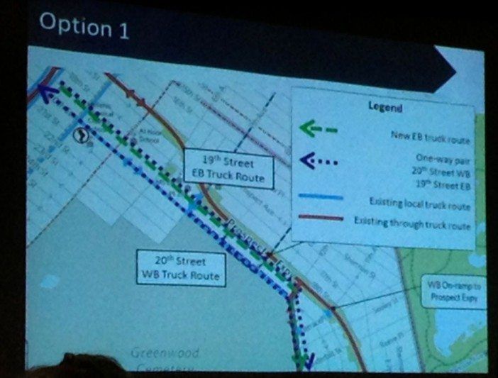
The DOT, along with traffic engineer associate Einah Palaez of engineering firm HDR, presented five possible options they’ve developed for 20th Street, but none offer the best solution just yet. The top two are the most promising, but there are some pros and cons that keep them from being ideal.
Option one, shown above, would turn 19th Street into an eastbound one-way truck route (it’s not currently a truck route) and 20th Street into the westbound one-way truck route, both between 3rd and 10th Avenues. That would have a minimal impact on one-way street patterns in the area, and wouldn’t impact existing bus routes or access to the Prospect Expressway along 19th. But the biggest issue here is that 19th Street has a number of schools, and the increased truck traffic would just worsen safety issues, like those currently seen along 20th Street — particularly around the former Bishop Ford High School, where new schools with younger children have been set up.
“Children in the school that was the Bishop Ford don’t have an outdoor play area, so they go into parks and need cross streets to get there. We’ve been working on getting them crossing guards and making that a much more secure passageway where stops have to be absolute,” said Madeline Seide, parent coordinator at PS 10 (located at 511 7th Avenue at 17th Street) and a local resident. “I live on Seeley Street, and I can tell you people do what they can to go and roll through. They’re not really stopping.”
This is also a concern of the DOT. Part of the overall scope of the study is to improve safety for pedestrians, too, which they want to include traffic calming measures, as well as adding sidewalk space to 20th Street (which would be allocated from the road space if the street ends up going one way).
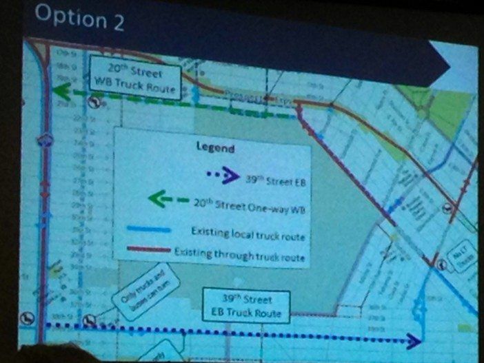
The second, and perhaps more promising option, is one that would turn 20th Street into a westbound one-way truck route, and 39th Street into an eastbound one-way truck route. That would also allow those sidewalk improvements on 20th, and would keep the truck activity on existing truck routes. The downsides here are the increased travel times for trucks and the impact this might have on 39th Street, particularly to the B35 and B70 bus routes that currently use it.
This is also the point where people raised a few important questions about use of these streets if they become one-way, including the impact on surrounding streets, whether it’s even possible along 39th Street without federal approval (because of its connection to I-278), and general safety.
“Your problem here is topography in that you’re dealing with two of the highest points on Long Island,” neighbor Tom noted. “If you’re going to establish a westbound one-way on 20th Street, that’s immediately a speedway. It’s downhill from 8th Avenue to the waterfront.”
Despite a lot of potential stumbling blocks, everyone seemed hopeful that there is some solution for a smarter design to make these streets safer. There was a general agreement to leave 19th Street as-is, and to change 20th Street into a one-way road, so long as there are traffic calming improvements to keep speeding from becoming a factor, and they’ll look at 36th and 37th Streets as an alternative to making 39th one-way.
The DOT’s next steps will be to conduct more surveys in the area and develop alternative options, and then they will hold more meetings like this one in the areas that will be directly affected. We’ll keep you posted about those as they’re announced.


